Welcome to Gujarat
Welcome

Rajasthan

North India

South India

East India

North East

Kerala

Gujarat

Kashmir

Ladakh

Himachal

Sikkim

Bhutan

Nepal

Tibet

Adventure

Bird Watching

WildLife

Safaris

Temples

Goa/Beaches

Special Tours

Train Tours

Ayurveda

Yoga

Festivals

Hotels

Car Rental

View All Tours

References

Himachal Tours

Enchanting Himachal Pradesh Tour

Himachal Pradesh Intensive Tour

Himachal Tour

15 Days Himachal Tour

13 Days Himachal Tour

12 Days Himachal Tour

Himachal Pradesh Tour

Himachal Trekking Tour

9 Days Himachal Tour

Himachal Short Tour

8 Days Shimla Tour

India Tours

31 Days Rajasthan

30 Days Gujarat

26 Days South

20 Days Rajasthan

19 Days North India

18 Days Rajasthan

17 Days South

16 Days Shekhawati

15 Days Himachal

14 Days North India

13 Days Sikkim

11 Days Nepal

9 Days Ladakh

8 Days Taj Triangle

4 Days Tibet

Travel Guide
Indian Architecture 
Indian Embassies
Flight Sickness
India Information
Nepal Information 
India Geography
Indian History
Media in India
 Modern History
Music in India
Musical instruments
Paintings of India
Reaching India
Refreshments 
 Religions
Shopping
Telecommunication
Temperature Guide 
Visa Information
Indian Wildlife

Travel Tools

Airlines in India

Railway Timetable

India Dialing Codes

Currency Converter

Distance Calculator

Time Converter

India Guide

About India

Himalaya

Plains of India

Western Ghats

India Civilisation 

Hindu Temple

The Stupas 

Rock Cut Architect

Cave Architecture

Adventure Tours

Himalaya Trekking

Rafting on Ganges

River Rafting

Rajasthan on Bicycle

Biking in Sikkim

India River Rafting

Cycling in Ladakh

Tons River Rafting

Ladakh Biking Tour

Garhwal Trekking

River Rafting Tour

Trekking in Ladakh

Indus River Rafting

Chandrabhaga River
About Chandrabhaga River

Chandrabhaga is one of the important rivers in Amravati district of Maharashtra. It forms a part of Tapti-Purna river system as a tributary of Purna.

The main stream of the river rises just down the Vairat plateau in the Chikhaldarahills and takes an eastward course draining the south slopes of Chikhaldara and Gawilgarh plateaus. There is a dam on the river as it comes out of the valley. The river takes a more southward turn from the dam and passes through the town of Daryapur before it meets with river Purna on the border of Amravati and Akola districts. Bhuleshwari is the main tributary of Chandrabhaga that meets it just before Daryapur. Bichan and Sapan rivers flowing through Paratwada and Achalpur are other affluent streams. This Chandrabhaga river is different from the Bhima river, which is popularly called as Chandrabhaga at Pandharpur.

 
Chandra and Bhaga River

The 
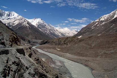
River Chandra is one of the two rivers which merge to form the Chenab in the Lahaul region of Himachal Pradesh. It rises in the snows lying at the base of the main Himalayan range in the 
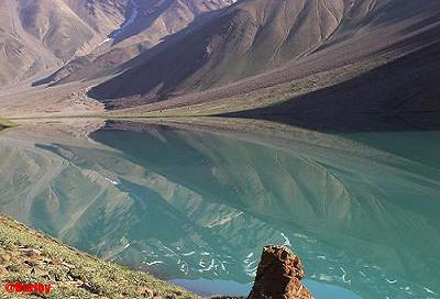
Lahaul and Spiti district. The beautiful Chandra Tal lake has formed at its source. It flows for a extensive distance along the base of this range in a southeasterly direction before turning completely and taking a southwesterly course in the Spiti Valley. It flows on to merge with the Bhaga River downstream of Keylong.

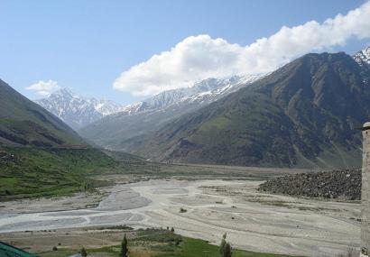
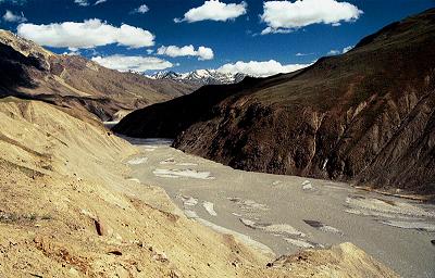
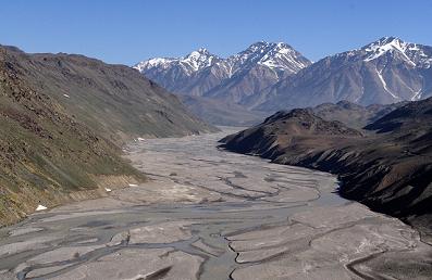
The upper and middle catchments of this river are made up of a topography that has been carved out by glacial action. The whole area is a vast cold desert that receives little or no rain as it lies in the rain-shadow of the Pir Panjal range lying towards the south. Many small snow-fed tributaries join the Chandra at different places.

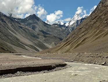
Describing its course, Harcourt (1871) states, "the river Chandra passes through a totally unproductive land where there are no signs of life, the solemn mountains fully clad in undying snow lying on its either flanks. No villages adorn its banks, no attempts at cultivation, no human life is met with and nothing greets the eye but the never ending tedious cliffs, which are lapped by the violent stream as it rushes in wild fury against 
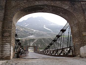
its banks". Koksar is the only important human settlement along this river.

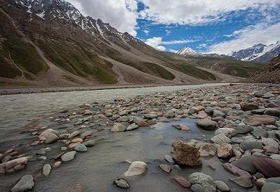
The Chandra river originates from a huge snow, bed on the south-eastern side of the Baralacha la and assumes a large size very soon. During the summer, it becomes unaffordable within a short distance, about two kilometers of its source, while the rocky bed, the icy temperature of the water and the swiftness of the current deter the boldest swimmer. Looking down the valley from the pass, a view of grand peaks and glaciers, on the right hand side, falling suddenly to the water's edge makes a memorable impression on the visitor. On the left hand, the slopes are bare the feet of which remain continuously covered under heavy mass of fragments falling from above.

Lower down, the Chandra Tal, a kilometre long and a half wide, lies in a broad lush plain, the lake is placed between a low ridge and the main Kunzam Range with an outlet into the river. Throughout its course the river is fed by a number of glaciers the biggest being the Shigri on its left bank, and the Samundari on the right. The main tributaries of the Chandra below Shigri lie on 
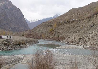
the right bank and they originate from the Sonapani glacier opposite Khoksar and the Sissue glacier. The left bank is steep 
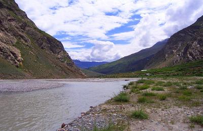
and bare, but there is good grazing ground on the right bank 
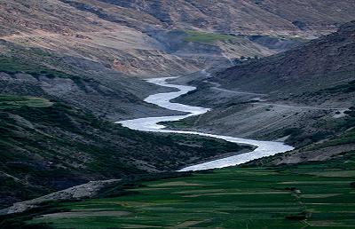
beyond Khoksar. There are several villages on the right bank as far as Sissue, and from Sissue the valley becomes richer and cultivable down to Gondhla. The villages grow larger as Gondhla is approached, and the houses are seen to be better built, enclosed by groves of poplar and willow. The northern mountains take gentler slope, but on the south, opposite Gondhla, the whole mountain side, from the peaks over 6,090 metres to the river bed below. 3050 metres, is visible. Glaciers and snowfields overhanging rocky steeps combine into grassy slopes below. At one point the cliffs descend for some 1,210 metres and form the grandest precipices in the world.

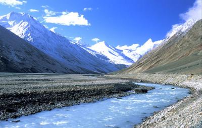
Bhaga river joins Chandra river in Tandi to form Chandrabhaga and later Chenab which is one of the fastest flowing rivers of India. It originates near Baralacha la at around 16000 feet above sea level. From its source to its convergence with the Bhaga at Tandi, the Chandra registers a fall of about 12.5 metres per kilometre.

Chandra River & Bhaga River Confluence (Sangam)

Chandra flows in from south east and Bhaga flows in from north east. The combined river is called Chandrabhaga and it flows to North west. Chndrabhaga in its lower reaches is called Chenab which is a major tributary of Indus River (Sindhu Nadi).

Chandrabhaga is borne out of love. It is said that the daughter of the moon ‘Chandra’ and the son of the Sun ‘Bhaga’ fell in love and decided to take a long walk circumambulating the holy mountains of ‘Lahaul’. After many a meandering course they fell into an undying embrace in their togetherness at ‘Tandi’ to give rise to ‘Chandrabhaga’.

As Chandrabhaga enters the plains of India in the land of five rivers namely Punjab, is known as ‘Chenab’. These five rivers are ‘Sutlej’, ‘Ravi’ ‘Jhelum’, ‘Chenab’, and ‘Beas’, all these finally join Indus in their journey towards the sea. The ‘Chenab’ out of these is the one, the banks of which are said to have encouraged the everlasting love stories of ‘Punjab’ namely, ‘Sasi-Punnun’, ‘Sahiba-Mirza’, ‘Sohni-Mahiwal’ and‘Heer-Ranjha’,. Some people even say that the waters of Chenab have a slight reddish touch brought about by the blood of eternal lovers. In legend and also in realty ‘Chandrabhaga’ continues to inspire lovers on its banks and around its portals.


Tours all over India – Nepal and Bhutan Home Mail to tourism expert of India e-mail  Online chat regarding travel and tours to India Chat Get contact information to Indian Tour Operator and Travel Agent Contact  Send your enquiry or tour request. Enquiry  Tour and Travel experts for India and Indian sub-continent About Us

Your feedback about travel and tours to India and Indian sub-continentFeedback

FAQ

Visit the site map of Indo Vacations Site Map India related and other useful links Links


www.indovacations.net
Copyright © Indo Vacations. All Rights Reserved.