|
|
|
Sikkim Trekking |
|
|
|
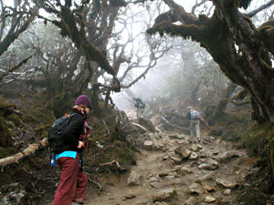
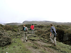
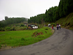
Trekking in Sikkim
The state of Sikkim is like a trekkers paradise. Sikkim
is the ultimate holiday destination for the trekkers
that offers easy and short trekking routes to the
trekking enthusiasts. While trekking one covers the
beautiful views of the snowy peaks, the spectacular
Himalayas, beautiful gompas, colourful hamlets, meadows,
forests and orchards. The trekking in Sikkim can be a
wonderful experience and its memories are cherished
lifelong. As you start trekking through the valley, you
would be able to notice that the mountains take up
strange and wonderful shapes and the beauty of the
Himalayas is unexpected. From a distance these mountains
may seem formidable and unapproachable but as you |
 |
|
|
approach near
them they seem to welcome you into the beautiful forests.
Technical climbing experience is not necessary as most of the
trek routes are between 6000 and 14,000 feet. The best time to
trek in Sikkim is between mid of February to May and from
October to December. The foreigners have to obtain permits for
trekking on most of the routes in Sikkim. Some of the famous
trekking routes in Sikkim are the Yoksum – Dzongri Trek, Tashi
View Point – Tinjure trek, Base Camp – Garakhet Trek, Phalut -
Singelila - Chiwabhanjang trek, Hilley - Varsey Trek and
Damthang - Tendong Trek.
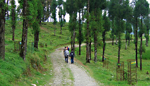
Tashi View Point - Tinjure Trek
Tashi View Point – Tinjure trek is a very easy trek that can
be comfortably covered on a day. This trek starts from the
Tashi View Point and ends at Tinjure and covers Animal
Husbandry Department, G.B. Pant Institute, Fambanglho Forest
Sanctuary. One has to reach Tashi View Point by vehicles and
then walk for a few kilometers on the road to Pangthang and
Dichkcu till the Log hut of the Agriculture Department. From
here the bridle path begins skirting the Experimental farm of
G.B. Pant Institute at a moderate steep and takes through the
dense Fambongala Forest Sanctuary in about two hours. The last
stretch of half an hour is rather steep and one has to cross
the trees that have fallen across the path. The ground is soft
and bouncy at some of the places. The trek ends at Tinjure.
Tinjure lies on the highest point on the Rumtek hill opposite
Gangtok, at an altitude of about 7500 feet. Tinjure has a
three storey wooden observation tower festooned with prayer
flags on concrete stilts and offers a breathtaking view of the
town of Gangtok. It overlooks both Gangtok and the Tista
valleys and on the northeastern horizon lies the Siniolchu
range. The trek back to Tashi View Point takes less than three
hours. |
|
|
|
Yoksum - Dzongri Trek
Yoksum – Dzongri Trek is not a easy track and can be
covered in one to two days. This trek starts from the
Yoksum and ends at Dzongri and covers Dubdi monastery
and Bakhim. There is a proper trekking bridle path
between Yoksum and Dzongri. The best time to take this
trek is from the months of April to June and September
to November. To start the trek one has to first reach
Yoksum by vehicles. Yoksum was the first capital of
Sikkim and the first Chogyal was consecrated here by the
three holy Lamas. The spot where this ceremony took
place in 1642 can still be seen here. Yoksum is also the
starting point of trekking. After reaching Yoksum, one
can start trek. Guides, porters, yaks, tents, sleeping
bags and other |
 |
|
|
trekking
equipment are also easily available for rent at Yoksum. From
Yoksum, a walk for about half an hour will take you to the
Dubdi monastery. This monastery is one of the oldest monastery
in Sikkim. After an hour of a flat track the climb begins. A
walk for another four hours on a path lined with trees takes
you to Bakim. From Bakim you have to trek for another hour and
reach Choka. Choka is a small village that consist of about a
dozen houses and a monastery. Most of these houses offers
accommodation and food at a nominal cost. One can stop at
Choka or trek further to Dzongri for about 10 kms. The trek to
Dzongri takes about 4 hours. Dzongri has only two trekker’s
huts without any other habitation. The bridle path at Dzongri
divides into two footpaths, the first path leads to the Base
Camp and the other path leads to the Goechela pass.
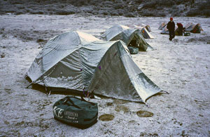
Base Camp – Boktak – Laxmipokari –
Garakhet Trek
Base Camp – Boktak – Laxmipokari – Garakhet trek starts from
the base camp. The base camp is located at 15000 feet about 9
kilometers away from Dzongri and takes about three hours to
reach. There are various trekker’s hut in the Base Camp which
are owned by the Himalayan Mountaineering Institute,
Darjeeling. From the Base Camp, a steep climb takes you to a
pass at about 17000 feet and a vertical, knee wobbling drop
enables one to reach deep down in a flat valley surrounded by
the huge granite cliffs. On the way you will also come across
a river. Another vertical climb up brings you at Khangerden
with its lone hut. This trek of 6 kms takes about three hours.
From Khangerden the trek to Boktak through Tiyabla is
relatively easy going and takes about six hours. If you start
early in the morning from Base Camp, you can comfortably reach
Boktak in the late afternoon. One can have a night stay in
Boktak. On the next day you can view the most beautiful lakes
in this remote area. A moderate climb of about two and half
hours through Chirpuk reaches you to the Majur Pokhari, the
banks of lake. This lake looks like the wings of a bird that
glistens brightly. No one has been able to explain this
illusion, but it is said that it is due to the reflection of
light. Above the Majur Pokari are two twin lakes called the
Ram-Laxman lakes. During the trek one will come across a
number of such twin lakes knwn as the Ram-Laxman lakes. Now
you will stop at |
|
Gomathang, one kilometer below on a riverside. On the
third day the steep climb from Gomathang will take you
to the Laxmipokari lake. Laxmipokari is such a big lake
that can be photographed very easily without using a
wide angle lens. A steep switchback trail from the rim
takes you to the lake-side where a small wooden temple
has been constructed. From Laxmipokari towards Garakhet
lies another relatively flat Ram Laxman lake and Bhut
Pokhari before you reach the pass. A moderate drop from
the pass takes you to Lampokhari lake, whose length is
considerably more than its width. Before you reach
Garakhet you pass by a small lake called the
|
 |
|
|
Haspokhari
which is in the shape of a swan. One can have an overnight
stay at Garakhet. On the fourth day you will walk up to
Timbong Pokhari, situated on the border of Nepal and Sikkim.
Timbong Pokhari is located about an hours walk from Garakhet
and this lake is considered to be very holy lake and is oval
in shape. Pilgrims from both Nepal and Sikkim visit this lake
regularly. Devotees have strung small bells on the lakeside as
it is believed it brings good luck. On the fifth day you will
reach Base Camp back from Timbong Pokhari with a night at
Boktak.
Phalut - Singelila - Chiwabhanjang Trek
Phalut - Singelila - Chiwabhanjang trek starts from Phalut and
ends in Chiwabhanjang. Phalut is situated near the trijuction
of Nepal, Bhutan and Sikkim. This trek lies on the ridge of
the razor-edged Singelila range that defines the boundary
between Sikkim and Nepal. Singelila is situated at an altitude
of 13000 feet which is the highest point on this route and
after which the whole western range of Sikkim is named. From
Singelila one can view the Mount Kangchendzonga that lies
above the valley, the Chola range in the east, hills of Nepal
in the west and the Nepal village of Cheng Thapu below the
range. On the Singelila range the air is in a continuous state
of turmoil. These clouds sometimes move from the Nepal side to
Sikkim and sometimes it is the other way round. You would also
be able to view the Yaks on your route. From Phalut, the trek
to Chiwabhanjang is only for about three hours. Chiwabhanjang
forms a pass to Nepal and two small lakes known as
Bhut-Pokaris are situated here. At Chiwabhanjang, an
inspection bungalow is located as a mute testimony of the
British presence here in the old days to keep off the Nepalis
from attacking Sikkim, which is now in ruins.
Hilley - Varsey Trek
Hilley - Varsey Trek lies in the south-western corner of Sikim.
This trek starts from Hilley and ends in Varsey. For the trek,
one has to first reach Hilley by road via Sombaria. The trek
from Hilley to Varsey is about four kilometers, about one hour
approximately. Varsey is located at an altitude of 10100 feet.
Silver firs, hemlocks, magnolia and rhododendrons are found in
equal abundance in Hilley but as one approaches Varsey, the
rhododendrons are mainly found there and during the month of
March they are a riot of red colour. A Lodge is also there at
Varsey and one has to walk a few hundred yards ahead to catch
a view to Chiwabhanjang on the Singalelah range. The village
of Burikhop can also be seen down the valley. |
|
|
|
Damthang - Tendong Trek
Damthang - Tendong Trek starts from Damthang and ends in
Tendong. Damthang is located about 14 kms from Namchi on the
Gangtok-Namchi (via Temi) road. One first has to reach
Damthang from Gangtok. From Damthang, one has to walk for
about one and a half hour on a footpath through thick forest
of the Tendong Forest sanctuary to reach Tendong. The forest
contains a variety of different species of vegetation. The
trunks and branches of trees are heavily festooned with
clinging beard like moss. Tendong is situated at an altitude
of about 8500 feet on a small plateau on the top of the
mountain. Tendong offers a beautiful view of the mountain
ranges like the Chola Range, the Singelia range, |
 |
|
Kangchendzonga range and the Gurudogmar
peak and as well as a breathtaking view of sunrise and sunset.
Darjeeling, Gyalshing, Nathula, a part of Gangtok and the
rolling plains of Siliguri can also be discerned from here.
From other parts of Sikkim, Tendong looks like a volcano and
according to the legends it was in fact once an active volcano
which is now dormant. There is also a story according to which
a man and a woman saved themselves on its summit during the
great flood that once inundated the world. Two small one-room
monasteries are also situated here. One of the monastery is
old and in the verge of ruins and the other one has been
constructed newly. An observation tower also has been
constructed here for the convenience of tourists.
Raongla to Maenam Bhaledunga Trek
Towering above the town of Rabongla, is the Maenam hilltop.
One has to trek three hours uphill from Rabongla through the
Maenam Wildlife Sanctuary teeming with Magnolia, Rhododendron
and small bamboo to reach the hilltop which is at an altitude
of about 10,600 feet. These trees, like giant sentinels seem
to guard the path. Flowers bloom over trees, like giant
sentinels seem to guard the path. While mosses, ferns and
creepers more reckless and more ambitious climb the soaring
trunks. A small hermitage containing the image of Guru
Padmasambva nestles here. The view from the Maenam summit is
picturesque and breathtaking. The town of Rabongla lies
sleeping far below and through the gaps in the mountains one
can see the rolling plains of West Bengal lazily stretching
out with the clouds resting on them. As the sun rises, these
clouds become buoyant and form a heavenly curtain of mist. In
the west the panoramic Kangchendzonga range presents a
celestial scene. A walk of another half an hour on the same
ridge takes on to Bhaledunga – peculiar looking cliff that
protrudes out and resembles the head of a cock. This
distinctive looking feature can be seen from miles away and
during the old days used to serve as a guiding landmark to
travelers. From the tip of this cliff, there is a vertical
fall of five to six thousand feet and one does require a
strong head to be able to look down from here. Far down the
river Teesta can be seen snaking its way like a giant python
through the valley. |
|
|
|
Trek
to Tolung Monastery
The Tolung Monastery was first built in the reign of
Chogyal Chakdor Namgyal in the early part of the
eighteenth century. It contains rare and valuable
scriptures and artifacts of other Monasteries that were
brought here for safety during the invasion of Sikkim by
the Nepalese during the late seventeenth century and the
early nineteenth century. A brass chorten within the
monastery contains the ashes of one of the incarnates of
Lama Latsun Chembo, the patron saint of Sikkim. All the
relics are kept sealed in thirteen boxes under the
supervision of the |
 |
|
|
Government of
Sikkim. Once every three years in the month of April the
relics are shown to the public in the monastery complex. The
last display of the relics was held in April 91. The old
monastery has been demolished because its structure had become
weak and a new one has been built in its place and the latter
was completed in April 91. Tolung at an altitude of 8000 feet
lies in the sparsely Lepcha populated Dzongu area of North
Sikkim and falls in the restricted area for which a Inner Line
Permit is required by Indian Nationals. To each Tolung, one
has to travel by road upto Linzey. There is a daily bus
service from Gangtok to a place slightly short of Linzey. From
Linzey to Tolung is a 20 kms walk and takes approximately five
hours along the thundering Tolung river through thick forest
and cardamom fields. The Track itself is easy but is
surrounded by precipitous cliffs from which plummet down
waterfalls in white plumes hundreds of feet into the narrow
gorges to the valley floor. Birds tweet louder to make
themselves heard over the sound of the waterfalls and the
rivers. Perched precariously on these cliffs here and there
are the huts of the hardy Lepchas. Time here itself seems to
move at a different pace. As one walks towards Toloun, the
surrounding mountains on the top of which ice clings
tenaciously even during the summer seem to close in. on
reaching Tolung one can understand why the Sikkimese chose
this place to keep the relics here out of the reach of the
invading Nepalese. It is so secluded and perhaps because of
its vantage location it was easy to guard. At Tolung there is
a Pilgrims Hut. A further walk of about an hour along the
Tolung river takes one to a religious spot called Devta Pani.
|
|