|
|
|
Suru Valley |
|
|
Information about Suru Valley
The Suru Valley is one of the most beautiful areas of Ladakh and a rather recent addition to the tourism map
of Ladakh. The Suru Valley forms the mainstay of Kargil
district. Lying nestled along the north-eastern
foothills of the great Himalayan Wall, it extends from
Kargil town, first southward for a length of about 75
kms Upto the expanse around Panikhar, hence eastward for
another stretch of nearly 65 kms upto the foot of the
Penzila watershed where the Suru valley rises. The hills
of Suru Valley are cultivated intensively than anywhere
else in Ladakh. Enough snow and water during the winters
and fertile land makes it possible to yield two crops
annually. |
 |
|
|
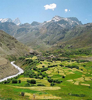
The valleys are especially
picturesque in spring when the apple, apricot and mulberry
trees are all in bloom and in autumn when they are laden with
fruits. Its composite population of about 30,000 - mainly of
Tibetan-Darad descent, are Muslims who had converted their
Buddhist faith around the middle of the 16th century. At
Thangbu, a little village, the traveler gets a first glimpse
of the spectacular Nun (7135 m) – Kun(7935 m) massif which
loom over the skyline in their crystalline majesty. Pahikhar,
about 12 kms. away is the base for treks to Kashmir and
Kishtwar. The road goes past the glaciers of the Nun-Kun
massif to descend to Rangdum gompa with a little stream
forming a moat around it, looks like an ancient fort
protecting the valley. Only the basic accommodation is
available at most of the tourist spots of Suru Valley.
Sankoo, Panikhar, Rangdum
and Padum in the Suru and Zanskar Valleys are the base for a
variety of trekking routes. The Suru Valley covers the
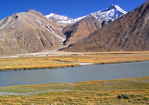
catchment area of the famous Suru River. Suru river originates
from the Panzella glacier. Before it joins the Indus River at
Nurla it is joined by numerous tributaries, including the Dras
River at Kharul. Suru Valley forms the mainstay of Kargil
district. The valley is nestled along the north-eastern
foothills of the Himalayan range and from Kargil. People
living in Suru Valley are mainly of Tibet and Darad descent -
most of them converted their religion in the 16th century. The
beauty of this Suru Valley region is further added by two
towering peaks of Kun (7035 m) and Nun (7135 m) which loom
over the skyline. The general topography and mountains in most
of the areas in Ladakh differs from the Suru Valley as Suru
Valley is relatively more fertile extending from the Panzella
glacier to south of Kargil town. In Kargil the Suru River
merges with the Botkul River which originates from the Botkul
glacier. The upper reaches of the valley, particularly around
the Sankoo bowl, the Panikhar expanse and the higher stretch
beyond, present a spectacle of breathtaking features -
majestic mountain ramparts crowned by snow capped peaks,
undulating alpine slopes draining into wild mountain streams
of foaming cascades of pristine water, awesome glaciers
descending along the Himalayan slopes to the river bed in
riverine formation, Quaint villages of adobe houses straggling
dry hillocks surrounded by large tracts of lush crops downward
the patches of alpine pastures uphill. |
|
|
|
The average altitude
of the Suru valley is 3,000 m. Winters are extreme and
heavy snowfalls are normal. Still the conditions in the
Suru Valley do not become as adverse as in the Dras
Valley. The winters begin around mid-November and end in
May. During winter, most of the valley is covered with a
thick layer of snow. The interesting development can be
observed as the water starts melting in the month of
may. During the first melting process one can see the
dark color which is obtained by the water
|
 |
|
|
and after it takes the blue
and green colour. In the month of September the water reflects
the best color and at the same time as it starts getting
cooler again the melting of the snow is also slowed down thus
water quantity becomes less. One of the factor that the Suru
Valley is fertile if compared with the other parts of Ladakh
is that summer lasts here longer than in other parts.
Agriculture is the main activity of the local economy and also
the main source of income for local people of the valley. In
some parts of the valley two crops can be yielded each year
unlike in other parts of Ladakh where sometimes it is
difficult to have even a single crop in the year. Main crops
of the Suru Valley are wheat, barley and millets. Some
initiatives have been taken to improve the wheat quality which
has increased the production of cereals. Some of the
vegetables grown here are turnip, radish, peas and black peas.
Grapes, apricots and melons are produced in fairly large
quantities at Darchik and Garkoon along the lower course of
the Indus through Ladakh. These find a ready market in Kargil.
Liquor is made from grapes. |
|
|
|
Mulbekh village
After crossing the Suru valley, the road leads through a sandy
plateau followed by another narrow valley and then one reaches
to Mulbekh village, which has an important monastery on a high
rock. The landscape round the settlement is characterised by
limestone masses that thrust up along fracture zones. Here the
religion dates back to the period when Buddhists missionaries
came travelling east of the Himalayas. The main attraction of
Mulbekh is the huge rock-cut sculpture of Maitreya. It is 9 m
high and depicts a standing Boddhisattva with four arms,
carved on a solitary finger of rock, with a headdress and
jewels. In the village of tidy whitewashed houses, there are
two Gompas. After reaching Mulbekh, one crosses Namika-La pass
situated at a height of 12,000 feet. Later, the road leads to
the highest pass on the Srinagar-Leh Road known as Fatula,
about 13,497 feet above sea level.
How to reach Suru Valley
The ideal way to reach Suru Valley is via Kargil. One has to
make the point to reach first Kargil. |
|


