|
|
|
Sikkim
Physical Features |
|
|
|
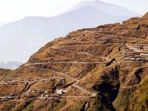
Sikkim has a very rugged topography due to
which there are very less flat lands. The rivers, mountains
are the main physical features that define the boundaries of
the state of Sikkim with its neighbours. Besides the rivers
and mountains, the lakes, glaciers, passes, hot springs and
waterfalls are also found in this region. |
|
|
|
Mountains in Sikkim
Sikkim is a land of the high mountains that seem to
touch the heavens and define the paradise of nature.
These mountains form a part of the Himalayas, the
highest mountain range. The Mount Kanchenjunga, the
third highest mountain in the world is situated in the
Sikkim. This mountain range can be seen from almost any
part of Sikkim and border the Sikkim from the northern,
eastern and western side. The two main mountain ranges
in Sikkim are the Singilela range on the Western border
and the undulating Chola range on the Eastern border.
The boundary between Sikkim and Bhutan is defined by the
Pangolia Range located in the south eastern part of the
state. Other peaks |
 |
|
|
that stand at
altitudes of above 20,000 feet are Siniolchu, Pandim, Kabru,
Rathong, Kokthang, Talung, Kanglakhang, Simvo and Jonsang. The
other imposing mountains that are slightly less than 20,000
feet are Masthonangye, Yabukjakchen, Narsing and Lamaongden.
Most of the peaks of Sikkim have remained unscaled as the
Sikkimese consider them sacred and feel that they will lose
their sanctity if climbed.
Mountain
Passes in Sikkim
The mountain ranges are interspersed with various passes which
can be used to cross from one side to another. The two most
important passes are the Nathu La and Jelep La pass located on
the eastern Chola range at an altitude of about 14,500 feet.
The Nathu La pass is also known due to the war between China
and India. Nathu La and Jelep La passes also formed a part of
the trade route between India and Tibet till 1962. The Bhutan
La pass is located at an altitude of about 13,000 feet. The
first two pass leads to the Chumbi valley in Tibet and the
third pass leads to Bhutan. Another important pass on this
range that also leads to the Chumbi valley is the Chola pass
which was used by the Chogyals to go to Tibet from Tumlong.
Chiwabhangjang is the another important pass located on the
west between the Sikkim and Nepal border. From this pass the
Nepalese used to attack Sikkim during the last century. The
other pass on the west is Kang la. |
|
|
|
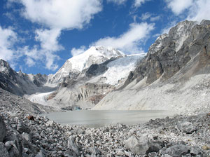
Glaciers in Sikkim
A glacier is a slow moving river of ice. The glacier
flows from high mountain peaks through rocky valleys and
carries unmelted snow, rocks and debris that has
compacted over many years into a solid, creeping ice
stream. According to some people, about thousand years
ago the whole of North Sikkim was covered with glaciers.
Lachung is situated at the base of an ancient moraine.
The most important glaciers in Sikkim are the Zemu
Glacier, Rathong Glacier and the Lonak Glacier in North
Sikkim. The Zemu glacier is the largest and the most
famous glacier of the eastern Himalayas. This glacier is
about 26 km in length and is situated in a large
U-shaped valley at the base of the Kanchenjunga |
 |
|
|
mountain in
the northwestern Sikkim. The Teesta River rises from the snout
of this glacier. Various icefalls and waterfalls have been
formed at the junction of the tributary glaciers with the Zemu
glacier.
Lakes in Sikkim
Sikkim has a rugged terrain but though still some lakes are
also found in this area. There are some lakes which are not
very large in size. These lakes are both spring fed as well as
river fed. They also form the source of many rivers. The
Changu Lake is situated on the highway between Gangtok and
Nathu-la, about 34 kms from Gangtok. The Bidang cho and the
Menmoi cho are the two other lakes which are also found in
Sikkim. Khechopari lake is another well known lake that lies
on a bifurcation of the route between Gyalshing and Yoksum.
Laxmipokari, Lampokari, Majurpokari, Ram and Laxman lake,
Cholamu and Green Lake are some of the beautiful lakes which
are also found in Sikkim. Gurudogmar lake is the largest and
probably the highest lake in Sikkim.
|
| |
|
Rivers in Sikkim
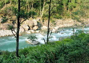
The rivers which are found in Sikkim are fed by the snow
melting on the mountains and also by the rains that
accumulates in the catchment areas during the monsoons.
The rivers of Sikkim are perennial and do not dry out
even during the winters. Some of these rivers also have
a potential of generating thousands of megawatts of
electricity. The two main big hydroelectric projects are
built on the Rangit and the Teesta rivers. The valleys
of the rivers towards the North of Sikkim are wide and
concave shaped due to the presence of glaciers millions
of years ago, but on moving southwards these valleys
transform into deep V-shaped gorges. The rivers are very
narrow, steep |
 |
|
|
and full of
rocks due to which they are not navigable. During the monsoons
these rivers become swollen, swift, muddy and dangerous. The
main river found in Sikkim is the Teesta river. When the
Teesta river approaches the border between Sikkim and West
Bengal it becomes wide and clear of rocks and it is possible
to raft across it. The Teesta finally joins the Bramaputra in
Bangladesh. The Teesta river flows almost right across the
Sikkim. The Teesta river orginates from the Cholamu lake where
it is hardly a stream. Its major tributary is the Rangeet
which originates from the Rathong Glacier and meets it at the
border between Sikkim and West Bengal. The Teesta river flows
in the North - South direction while its tributaries flows in
the South West or South East directions. The river Ramam, a
tributary of Rangeet river and Rangpo chu, the tributary of
Teesta river defines the Southern border between Sikkim and
West Bengal. The other smaller tributaries of the Teesta river
are Zemu chu, Lachung chu, Talung chu, Bakcha chu. |
|
|
|
Hot Springs in Sikkim
Sikkim has various hot springs which are known for their
medicinal and therapeutic value. The most important hot
springs are located at Phurchachu (Reshi), Yumthang, Ralang
and Momay Samdong. All these hotsprings have high sulphur
content and are located near the river banks. The average
temperature of the water in these hot springs is 50 degrees
Celcius. These springs are considered holy as one of the four
holy caves is located here. This holy cave is called the
Kadosangphu or 'cave of the occult fairies' and lies on the
south of the four cardinal points. The Yumthang Hot Springs is
the famous hot spring located at an altitude of 12000 feet in
the North Sikkim. To reach at this place one has to cross a
few hundred metres off the road and cross a bridge. At this
place a small hut is situated where the hot water is collected
in a pool, where one can take a dip.
Waterfalls in Sikkim
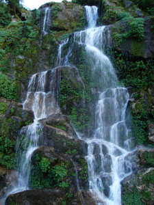
The verdant green landscape of Sikkim is broken by the
waterfalls that leap out of the hillsides in the valley. Most
of these waterfalls |
 |
|
|
are perennial, fed by the spring
water and snows which melt on the mountains. These waterfalls
can be found almost all over the Sikkim but some of the waterfalls
are found in the North Sikkim specially on the road between
Mangan and Lachung as well as in the Dzongu area. |
|
|
|
 |
|
Car Rental
|
|