Welcome |
|
|
|
|
|
|
|
|
|
|
|
|
|
|
|
|
|
|
|
|
|
|
|
|
|
|
|
|
|
|
|
|
|
|
|
|
|
|
|
|
|
|
|
|
|
|
|
|
|
|
|
|
|
|
|
|
|
|
|
|
Kasaragod |
|
Information about
Kasaragod |
|
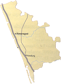
Kasaragod is
the northernmost district of Kerala and
overlooks the Arabian sea. This district is an entry
point for the tourists who are coming from the north to the
enchanting state of Kerala. The name "Kasaragod" is
derived from the word Kusirakood which means the
Nuxvomica forests (Kanjirakuttom). It covers an
area of 1961 square km. Kasaragod is bordered by the Arabian sea in the west, in the east by
the forested slopes of the Western Ghats, in the north
east by Karnataka and in the south by Kannur.
Kasaragod is mainly known all over the world for its
coir and handloom industries. Kasaragod is also known as the land of gods, forts, temples, rivers,
hills and beautiful beaches.
This place is like a heaven where nature still plays an
important part in the everyday life. It is a very beautiful
place with forts, rivers, forests, palm trees and beaches.
Kasargod is rich in folk-culture, visual arts and festivals.
Most of the people in Kasaragod are farmers and grow various
crops like Coconut, Rubber, Paddy, Cashew, Pepper, Vegetables,
etc. Besides farming,
fishing is also the main source of livelihood of the people
in Kasaragod.
Hindus, Muslims and Christians are the three types of
religions found in Kasaragod.
Malayalam, Kannada, Tulu, English, Hindi, Konkani are the major
languages of the district.
The best time to visit Kasaragod is between September
and January.
|

|
|
|
|
Tourist
Attractions in Kasaragod |
 |
The
major tourist attraction in Kasaragod are the Bekal
Fort, Bekal Fort Beach, Kappad Beach, Ananthapuram Lake Temple,
Manjeswaram, Kanwatheertha Beach, Kanhangad
or Hosdurg Fort, Ranipuram, Sree Mahalingeswara Temple,
Cheruvathur, Possadigumpe, Tulur Vanam, Pandiyan Kallu,
Nileswaram and Malik Deenar Mosque. There are variety of
styles in the architecture of the temples in Kasaragod.
The Madhur Mahaganapathy Temple, and the historic Malik
Deenar Great Juma Masjid displays a unique and typical
Kerala style of architecture.
More....
|
|
|
|
Backwaters in Kasaragod |
|
Valiyaparamba Backwaters is situated about 30 kms from Kasaragod. It is
one of the most scenic backwater stretches in Kerala. It is fed
by four rivers and dotted with numerous little islands. It is
one of the most famous tourist destination in Kasaragod and
offers enchanting boat cruises. Chandragiri also offers
enchanting boat cruises to the nearby islands and palm groves.
Chandragiri is situated on the Chandragiri River, southeast of
Kasaragod town. This town is known for its large 17th
century fort built by Sivappa Naik of Bedanore. The Chandragiri
Fort is built by the Sivappa Naik and offers a breathtaking view
of the river and the Arabian Sea. It is a perfect point to watch
the sunset. |
 |
|
|
|
Festivals in
Kasaragod |
|
Some of the festivals celebrated in Kasaragod are
Pattutsavam, Madiyan Kovilakam, Kanhangad, Chaliyaporatu
festival, Palakunnu Bharani, Nileswar Poorakali, Utsavam, Pooram,
Theyyam, Kanathur Theyyam Kaliyattom, Kalom Kanipu Utsavom.
Pattutsavam, Madiyan Kovilakam, Kanhangad are the nine day
annual festival, celebrated in January. The main features of
this festival are the cultural performances, religious rites and
grand elephant processions. Chaliyaporatu festival is named
after the popular folk art, prevalent in North Kerala. This
annual festival is celebrated in March. Palakunnu Bharani
festival is marked by processions and brilliant fire works. The
Theyyam festival is performed in houses, tharavads and shrines.
Nileswar Poorakali is a folk dance of men performed at the
Nagacherry bhagavathy Temple. This dance is performed in the
last week of March to the first week of April. |
|
|
|
How
to reach here |
|
By Air:
The nearest airport is located at
Mangalore and Kozhikode, about 50
and 200 kms. respectively.
By Rail:
The railway station is located
on the Kozhikode-Mangalore-Mumbai route.
By Road:
An
excellent network of roads connects Kasaragod to major towns in
Kerala, Karnataka and Tamil Nadu. |
|
|