|
|
|
Nagaland |
|
|
Information about Nagaland
Nagaland, a rural state is situated in the extreme north
east India. Nagaland is one of the smallest state in
India, with a total area of 16,579 square km. This state
is bordered by Assam in the west and north, in the east
by Myanmar (Burma), in the north by Arunachal Pradesh,
and in the south by Manipur. Nagaland is a narrow strip
of mountain territory between Assam and Burma and a
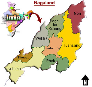
population of over one millions. The state is divided
into seven districts which are Kohima, Phek, Mokokchung,
Wokha, Zunheloto, Twensang and Mon. Kohima is the
capital city of Nagaland. Dimapur is the principal entry
point for Nagaland and an enchantingly beautiful hill
city. Its colorful people, great verdant landscapes,
cultural festivals and tribes are a delightful
combination for a delightful holiday experience. The
state is inhabited |
 |
|
|
by a variety
of Tibeto-Burmese tribes speaking over two dozen dialects.
Nagamese, Hindi, English, Chang are the various languages
which are spoken in Nagaland. Nagaland has a monsoon climate
with generally high humidity. The best time to visit Nagaland
is from September to April. The foreigners require area permit
to visit Nagaland.
History of Nagaland
Very little is known about the early history of Nagaland.
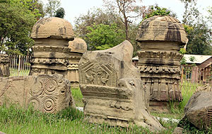
Dimapur is a prosperous trading centre and was once the
capital of Cachar, a Hindu Kingdom. The Cacharis, one of the
Naga tribes, were strong enough to raid the neighbouring Assam
and Burma. But by the end of the 17th century, the Ahoms of
Assam were able to subdue them. When the British intervened in
Assam, they set up a post at Kohima. This post too came under
the Naga siege. But, a permanent peace was established between
the two parties in 1889. The British rule was established over
the area by the 1890, and head hunting, a traditional
practice, was outlawed. During World War II, the Japanese and
the Indian National Army joined hands to attack Kohima and in
1943, they occupied more than half of the city. They also
attacked Imphal. The objective was to take over Dimapur which
was a vital rail-head for reaching supplies to British troops
in the forward areas. The Naga territory was divided between
Assam and the North East Frontier Agency after Indian
independence in 1947, despite of the movement which provided
the political union of all the Naga tribes. After
independence, some Naga groups demanded autonomy, and later
independence. |
|
In
1957, following violent incidents, the Indian government
established a single Naga administrative unit under
Indian rule. The Naga people responded by refusing to
pay their taxes and by conducting a campaign of
sabotage. In 1960, the Indian government agreed to make
Nagaland a self-governing state within India. Nagaland,
the 16th state of the Indian Union was born on 1st Dec
1963. The Naga separatists continued to show violent
opposition and demanded for autonomy and creation of a
single administrative unit comprising all the Naga
inhabited areas spanning across some of the north
eastern states. |
 |
|
|
For some
years, a state of insurgency prevailed but in 1975, the Naga
rebel groups agreed to accept statehood within the Indian
Constitution. The Naga rebels and the Indian government agreed
on a ceasefire, but peace talks are still going on. Nagaland
has a single-chamber Legislative Assembly with 60 seats. The
state sends two members to the Indian national parliament, one
to the Rajya Sabha (upper house) and one to the Lok Sabha
(lower house). Mokokchung, Tuensang, Mon, Wokha, Zunheboto,
Phek and Kohima are seven local government administrative
districts in Nagaland. |
|
|
|
Geography of Nagaland
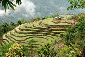
The terrain in Nagaland is hilly, thickly wooded,
rugged, and cut by deep river valleys. The Naga Hills
run through this small state. From Dimapur which is in
the plains and the gateway to the state, the road leaves
the tea gardens and rises up wooded mountains. There are
green valleys with meandering streams, high mountains
with deep gorges and a rich variety of flora and fauna.
The Saramati is the highest peak in Nagaland which is
located at a height of 3840 metres above sea level. The
main rivers that flow through Nagaland are Dhansiri,
Doyang, Dikhu and Jhanji. The terrain is |
 |
|
|
mountainous,
thickly wooded, and cut by deep river valleys. There is no
waterfall in Nagaland. The only well known lake in Nagaland is
Lacham, located to the east of Mehiri. The hill sides are
covered with green forests. The terraced fields can be seen in
the Angami region.
Festivals
of Nagaland
The festivals of Nagaland are mostly related to agricultural
operations. The community as a whole participate in the
festival celebrations. There is a definite programme that
stretch over a specified period in which all the village folk
join. The main festivals of Nagaland are Moatsu, Sekrenyi,
Sankarni. The Chakhesang Khilunyie and Rengma Ngadah are the
harvest festivals of Nagaland. The most important festival of
Aos is Moatsu, which is celebrated after the sowing is over
for six days.
Cities in Nagaland
Kohima, the capital city of the state of Nagaland, has a
number of sites that are worth visiting to get an insight of
the place's rich history. The sites near Kohima include the
tribal villages of Khonoma, Dzulekie, Jopfu Peak, Dzukou
Valley and Dimapur. Dimapur is the principal entry point for
Nagaland. Dimapur is a prosperous trading centre and has a
mixed population. |
|
|
|
People of Nagaland
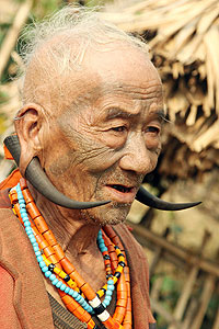
The people of Nagaland are the Nagas. A majority of the
people of Nagaland are Christians, though originally
they were animists. The Nagas belong to the
Indo-mongoloid family, a race whose presence was first
noted ten centuries before Christ, at the time of the
compilation of the Vedas. Nagas were the fierce warriors
and also the notorious head hunters. About more than 20
tribes and sub tribes comprises of Nagas, each tribe has
a specific geographic distribution. The Konyaks are the
largest tribe, followed by the Aos, Tangkhuls, Semas,
and Angamis. The various other tribes are the Lothas,
Sangtams, Phoms, Changs, Khiemnungams, Yimchungres,
Zeliangs, Chakhesangs (Chokri), and Rengmas.
Art
& Crafts of Nagaland
The important handicrafts of the Nagas are wood-carving,
bamboo work, pottery and blacksmith. The best
wood-carvings can be seen on the village gate, in the
Morung, and in front of the house of a rich man or
warrior. The forests in Nagaland are rich in Bamboo and
cane so Nagas are the expert basket makers. Apart from
the baskets, the |
 |
|
|
Nagas also
make mats, shields, chungas or drinking cups, necklaces,
armlets and leggings with bamboo. Pottery is not very popular
and is practiced in very few villages. Blacksmith, a
comparatively recent craft, is more popular in Nagaland. The
smiths produce the normal requirements of villagers like the
Dao, axe, sickle, knives, spear points, butts and
muzzle-loading guns. The Konyaks are the best blacksmiths.
Villages
of Nagaland
The villages are situated on hill tops and ridges and are
protected by stone walls. One such village, Bara Basti, can be
seen a few kilometers outside Kohima. Often the first building
one comes across in a village is the morung, a building with a
single huge cross beam often as much as 20 m long and 10 m
high which served as as the most important meeting house in
the community. It was also used as a boys dormitory, for
storing weapons and displaying the prizes of war in the form
of enemy heads, often as many as 150 in any morung. Since the
longhouses were constructed out of timber, bamboo and thatch,
the record in the form of skulls would often be destroyed in a
fire, when it would be substituted by carving small replicas
to retain the good fortune which otherwise would be lost. The
huge sacred drum which stood by each morung was hollowed out
of a tree trunk and carved appropriately to resemble a buffalo
head. |
|
|
|
Dances of Nagaland
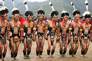
The Naga tribes are fond of dances. These dances are
mainly performed by men in a group, except in Zeliang
tribe where this dance is performed equally by men and
women. The Zemis of North Cachar hills are very fond of
dances. There are a number of dances and each with a
different name. They are named after the manner in which
hands and feet are executed to resemble the movements of
a bird or an insect or an animal like Nruirolians or
cock dance, Gethinglim or cricket dance, Temangnetin or
the fly dance and Hetateulee or the bear dance. All
these dances are performed with the songs and music. |
 |
|
|
|
|
Wildlife
Sanctuaries in Nagaland
The Intaki Wildlife Sanctuary is the major wildlife sanctuary
of Nagaland. This sanctuary is the home of many endangered
species of wildlife. It is located around 37 km from Dimapur
and is the habitat of Hoolock Baboon, the only gibbon found in
India. The sanctuary also has a sizeable number of tuskers,
tigers, mithun, Sambhar, wild dog and sloth bear and some rare
species of birds. Besides this, the Ghosu Bird Sanctuary is
another sanctuary in Nagaland. This bird sanctuary is solely
maintained by the village community. This sanctuary is the
habitat of more than twenty species of endangered birds. Fakim
Wildlife Sanctuary is located close to the Myanmar border and
inhabited by tigers and Hoolock gibbons. This wildlife
sanctuary receives high rainfall. |
|